
Occitaine is located in the south of France, bordered to the north with Auvergne-Rhône-Alpes, to the northeast with Provence-Alpes-Côte d’Azur, to the east with the Gulf of León (Mediterranean Sea), to the south with Andorra and the Pyrenees mountains that separate it from Spain, and to the west with New Aquitaine, that offers a perfect space for hiker.
This region is not only close to Spain, but also privileged with more than 30,000 km of marked trails, where nature and geography will never cease to amaze us.
It does not matter if we are in the center of Toulouse or visiting the hidden Cevennes, we can always put on our boots and go for a walk there.
The trails of Occitania stand out for their environmental interest in terms of flora, fauna and wonderful landscapes, but also they are full of history, legends and traditions.
For that reason, from Walkaholic we tell you about some of its best routes.
Contents
The Stevensonˈs road in the Cevennes
The GR-70 lays on the path traveled by the writer Robert Louis Stevenson, famous for “The Treasure Island”, in September 1878 and later popularized in his story “Travels with a donkey in the mountains of the Cevennes”.
This route should be done by stages, since it’s more than 260 km long. It goes from north to south from the Puy-en-Velay to Alès, crossing 195 km through Lozère and the rest in Gard, 2 Occitanian departments.
It runs through the middle of the mountain, at an average altitude of 1,000 meters, showing the hikers the landscapes of Gévaudan, Monte Lozère and the Cévennes until they reach the garrigue of the Gard.
The lakes of the nature reserve of Néouvielle

This path rewards those who overcome it with wonderful landscapes of lakes at 3,000 meters high.
Being a 4-hours-long walk, the route starts in Saint-Lary Soulan to go to the Aure valley, right in the parking lot of Lake Orédon, at 1,800 meters altitude. After about 30 minutes of walking you will reach the laquettes of Néouvielle, to continue to the dam of Lake Aubert, facing the Pic de Néouvielle (3,091 meters).
Then you should border the lake of Aumar until the port of Estoudou (2,260 meters), take the GR-10 to descend to the lake of l’Oule and from there you will return to the starting point in the Orédon parking lot. The difference is 400 meters, and this route is best to be done from May to the end of October.
Discovering the Templars

This route is marked as the GR-71, and begins in the Aveyron, near the Millau viaduct.
Touring the Larzac region, the route runs through cities built by the Templars in the twelfth century: La Couvertoirade, Sainte-Eulalie-de-Cernon and La Cavalerie.
In the Parc Naturel Régional des Grands Causses, two variants of this road can be chosen: the Templar and Hospitable GR 71-C, with approximately 80 km in length, to be traveled in 4 days, or the GR 71-D Tour du Larzac, with approximately 110 km to overcome in 6 stages.
Visiting Pont d’Espagne

The French zone of the High Pyrenees is particularly wealthy in water resources. So, that it is said that the Spaniards traded with the French, exchanging oil for water.
What is certain is that the Pont d’Espagne (at 1,496 meters) was built in the municipality of Cauterets as a trading post between the two countries, and it is a beautiful and worthy place to visit.
Located in the National Park of the High Pyrenees, close to the valleys of Cayan and Marcadau, after the Pont d’Espagne it is a good plan to continue to Lake Gaube.
It is a 1-hour walk and medium difficulty, but as a reward we can rest and regain strength in the restaurant / bar Hotellerie du Lac de Gaube, on the shores of the lake or you can even cheer up and go a little further, to the Oulettes de Gaube refuge on this route of 8.3 km.
Ascent to Puig Peric and Petit Peric
The Puig Peric, with its 2,810 m of altitude, is located in the Carlit massif, near the border with the Donasà in País de Foix, Occitania.
Overcoming it and then conquering the neighbor Petit Peric (2690m) is a challenge classified as medium/ high difficulty, demanding and with some technical complexity, so this circular route is recommended only to experienced hikers.

The total route is just over 15 km, but due to the accumulated slope of 1067m and the obstacles on the route it is designed to be completed in about 5 hours. However, the landscapes from the peaks are simply wonderful and worth the effort.
The route begins from the Font Grossa to reach Lake Balmeta, the Pond of Llosa and climb the Puig Peric (2810m). After overcoming it, we have to, reach the Petit Peric, to return to the Pond of the Duck and then return to the lake of Balmeta as a starting and returning point.
In the Cathars footsteps
The GR 367 trail is known as the Cathar route (Sentier Cathare), and preserves nowadays the memory of this movement, considered heretical in its time.
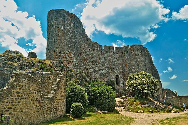
The Cathars preached that creation was guided by both God and Satan, so salvation was in shunning the material world. They were so successful in their preaching in Occitania that the cross of their movement represents the region today.
The Cathars were vanished by the Albigensian Crusade in 1209, but their legacy persists. It can be seen along this path, which starts in Port-la-Nouvelle, in the Mediterranean, and reaches Foix, in the Pyrenees. The Cathar castles of Quéribus, Peyrepertuse, Montségur, Roquefixade and Foix are scarce through this route of approximately 244 km.
Among them is Montségur, a castle in Ariège, south of Toulouse, where the final episode of the crusade against the Cathars took place. After conquering the fortress, the last of those heretics were burned on March 16, 1244.
Of course, in a single article it is impossible to travel all the wonders that Occitania has reserved for a hiker.
But on the official website of the Regional Committee of the Randonnée Pédestre d’Occitanie you can find fiches itinéraires (itinerary cards) that will help you organize new adventures.
But if you know a route that we have not mentioned and you want to share it with all your Walkaholic friends, do not hesitate to leave us a comment. So, maybe one of these days we will meet on the road, enjoying one of the magnificent hiking trails that the south of France offers.
Apúntate a nuestra newsletter semanal
Te enviaremos un correo cada semana con el nuevo artículo junto a las novedades de nuestra app móvil de senderismo.