Cambodia Elephant Sanctuary at Mondulkiri province

Back in 2015, one week from now, I left Europe for first time. It was a big deal for me, since I had been exploring many regions all around my continent, but never went out of it. I wanted so badly to go to Asia, it had always called my attention, but I didn’t really want to go to the typical tourist spot. Plus I needed to find inner peace at that moment of my life. So going to a country that not many people visit sounded like the right thing to do. So I chose Cambodia, and visited a Cambodia Elephant Sanctuary.

During the first week of my trip, I had been going North. After the capital, Phnom Penh, I departed to the Stung Treng province, where I enjoyed the 4.000 islands of the Mekong river. And then I was for a few days in Banlung, at the Ratanakiri Province, where I had the pleasure to see a few waterfalls and a volcano with a forest and lake in it. However, one of the most exciting parts of my first Asian trip was about to arrive. I ended up in the Mondulkiri province, basically because I heard it was atypical of Cambodia. It wasn’t so hot, neither so low (in altitude) as most of the country.

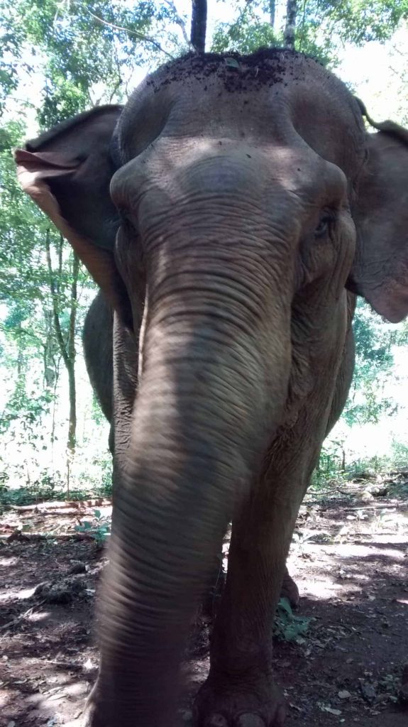
What is an Elephant sanctuary?

Princess is probably the most lovely elephant Mondulkiri

Continue reading Cambodia Elephant Sanctuary at Mondulkiri province

The Great Trail, a network in Canada of 24.000km of trails

In 1992, an extensive network of trails started to be created in Canada. It’s original name was the Trans Canada Trail, although since 2016 has been renamed to The Great Trail. It’s a 24.000km network of trails that connects the 10 provinces and 3 territories of Canada. The web of the project is https://thegreattrail.ca

It’s not only a hiking friendly project, but more a pedestrian path/canoe route/biking trail. Little more than a third of the total amount of kilometers, 8.500, are next to roads or highways. 7.000km are categorized as waterways, including the famous Lake Superior, which is commonly know as the largest lake in the world. And the rest 5.000km, are considered of various types.

Video of the project

Continue reading The Great Trail, a network in Canada of 24.000km of trails

Puig Campana to Ponoig trek

Last April, I went with a very good friend of mine to do a trek near my hometown. I grew up in the province of Alicante, in Southeast Spain. In a very tiny town named Xirles, 15km off the coast. My friend and I wanted to sleep at the mountain, in order to do a longer trek, and enjoy the evening. So we hiked two of the most relevant mountains in the area. Puig Campana and Mount Ponoig (Sleepy Lion in English, or “León Dormido” in Spanish).

Puig Campana is a mountain with an elevation of 1,406 m (4,613 ft). And Mount Ponoig is 1,181 m (3,874 ft). These mountains are very close to each other. From top to top, the shortest walkable distance is only 4,11km.

Legends of Puig Campana

Among the locals, there are a few stories that talk about the mountain of Puig Campana. I’ve even checked in the Wikipedia, in order to see if some match the one I remember since I was a child. But none fit, although they are very close between each other in the essence of the myth.

Puig Campana legend and it's missing chunk
Puig Campana legend and it’s missing chunk

Continue reading Puig Campana to Ponoig trek

Kyoto Trail – A variety of green and fresh hiking paths

Back in October 2016, I was at the last part of my Japanese trip, and I did part of the Kyoto Trail. I normally go to places with local immersion in mind, so my trip to Kyoto wasn’t going to be less. I sent a couple of CouchSurfing requests in order to get hosted and/or visit the city with the hand of a local. And the good luck was with me this time.

I had the great pleasure to meet Hiroshi (Hiro for friends), a local. Well, he isn’t really from Kyoto, but had been living there for 4 years at that time. So he knows very well the city and it’s surroundings. He and I became a good match even while talking via CouchSurfing and other messaging apps. He liked walking here and there. Getting into local places, no matter if they were very popular or not. Moving through the cities with a bycicle or on foot. And of course, hiking.

Sunset at the Eastern Kyoto Trail

Sunset viewpoint near the Eastern Kyoto Trail

The first afternoon we spent together, he brought me to a viewpoint at eastern part of the city. It is actually very near to the eastern track of the Kyoto Trail. And we enjoyed the sunset views with a small bottle of sake 🙂 Continue reading Kyoto Trail – A variety of green and fresh hiking paths

Social hiking – A Platform For Connections

“When architects want to strengthen a decrepit arch, they increase the load which is laid upon it. For thereby the parts are joined more firmly together.”

Viktor Frankel (Man’s Search For Meaning)

The Hiking “Drug”

If alcohol is a social lubricant, then hiking is a social binder. To go on a hike with a group of people, facilitates the forming of connections in a unique manner.

You’re out there in nature, committed to a mutual endeavor.

When we remove ourselves from our regular “habitat” (the city), and spend a period of time in nature, we respond immediately. Our body reacts to the change of environment as if we were on withdrawal from the city.

It’s very common to feel a sense of unease, in the first hours of a walk. That initial shift challenges our system, and makes us adapt our mindset to the new context.

To go through that transition with a group of people, has impacted me greatly during this year. I had the chance to go on hikes in Spain, Switzerland, Chile and Colombia.

Each time, with different groups or individuals in different contexts. These experiences have educated me on the “magic” of hiking.

We go in as strangers, and we leave as friends, or sometimes even brothers. Continue reading Social hiking – A Platform For Connections

Esta web utiliza cookies propias y de terceros para su correcto funcionamiento y para fines analíticos y para fines de afiliación y para mostrarte publicidad relacionada con sus preferencias en base a un perfil elaborado a partir de tus hábitos de navegación. Contiene enlaces a sitios web de terceros con políticas de privacidad ajenas que podrás aceptar o no cuando accedas a ellos. Al hacer clic en el botón Aceptar, acepta el uso de estas tecnologías y el procesamiento de tus datos para estos propósitos. Ver
Privacidad
Walkaholic App Offline hiking maps